2026-07-16 13:01:23
Latest Post
 GRE Renew Enertech Reports 100 MWp Solar Portfolio; Consolidated EPC Order Book of 75 MWp, Worth Approximately ₹224 Crore
 Mobavenue AI Tech Opens Singapore Hub to Scale AI-Native AdTech Across Southeast Asia
 Powerica Secures 100MW Wind Project bid from SECI's Wind Power Tender
 ACME Suryodaya Pvt Ltd commissions 110.336 MWh capacity of BESS project
 Arisinfra Solutions Ltd secures order of Rs. 79.05 crores
General
Deep Depression to cross coast between Kanyakumari and Pamban
Posted On : 2009-12-13 04:37:15( TIMEZONE : IST )

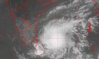 The deep depression over southwest Bay of Bengal slightly moved southward and lay centred at 1130 hours IST of today, 13th December 2009 near lat. 9.00 N and long. 83.00 E, about 200 km east-northeast of Trincomalee (Sri Lanka), 400 km southeast of Nagapattinam and 400 km east of Pamban. The system is likely to move in a westerly direction and cross north Sri Lanka near Lat. 9.00 N around early morning of tomorrow, the 14th December, 2009. Subsequently, it is likely to move in a west-southwesterly direction, emerge into Gulf of Mannar and cross south Tamil Nadu coast between Kanyakumari and Pamban around early morning of 15th December, 2009.
Under its influence, rainfall at many places with isolated heavy to very heavy falls is likely over north coastal Tamilnadu and Puducherry during next 48 hours. Rainfall at many places with isolated heavy to very heavy falls is also likely over south coastal Tamil nadu during next 24 hours. Rainfall at most places with scattered heavy to very heavy falls and isolated extremely heavy falls ( ≥ 25 cm) is also likely over south coastal Tamilnadu for the subsequent 48 hours.
Squally winds speed reaching 55-65 kmph gusting to 75 Kmph are likely along and off south Tamil Nadu coast during next 48 hours . Squally winds speed reaching 50-60 kmph gusting to 70 kmph is also likely along and off north Tamil Nadu and Puducherry coast during next 24 hours. Sea condition will be very rough to high along and off south Tamil Nadu coast and very rough along and off north Tamil Nadu and Puducherry coasts.
Damage expected: Minor damage to loose and unsecured structures
Action suggested: Fishermen are advised not to venture into the open sea.